Facts about the trip:
Team members: Dr Peter Schoedl, Dr Nathalie Marik
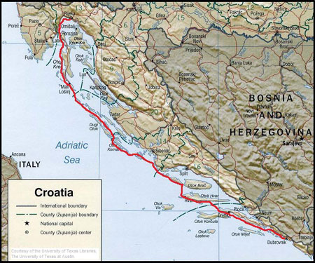
Expedition start: 9 July 2009 from Medveja, southwest of Rijeka
Arrival at Dubrovnik: 3 August 2009
Coastal ferry back to Rijeka: 6 August 2009
Arrival in Rijeka by ferry/paddling back to Medveja: 7 August 2009
Essential information:
We started our trip in Medveja, approx. 20 kilometres southwest of
Rijeka. The small village is easy to find, since it is located along the
coast road. The big advantage of this starting point is its protected
beach for launching and a campsite just across the street, with a
supermarket right next to it. We parked our car for the duration of the
trip behind the reception building for a small fee.
Distance:
Total paddling distance: 313 nm (563 km) – 20 legs.
Camping and accommodation:
Wild camping is officially not allowed! As ocean paddlers we can reach
hidden spots and pitch our tent in solitude. Obey the common wilderness
camping ethic – leave no trace! Ask for permission if there are
any houses nearby. We camped 13 times in solitude on pituresque beaches
and on rocky platforms along the more rugged coastlines without any
problems.
Accomodation in fishing villages and coastal
towns along our route (with all facilities):
Mali Losinj (Island Losinj): campsite Kredo (small cabin), Sali (Dugi
Otok): private appartment, Primosten (Mainland): 1970s style hotel, Hvar
(Island Hvar): private room, Korcula (Island Korcula): hotel, Dubrovnik:
hotel.
All our accomodation was close to the shoreline or
directly on the coast (exception: our appartment in Sali).
Important: Carry enough water, especially if you
decide to venture into more remote areas.
Getting back:
The Jadrolinja ferry company offers transportation along the whole
coastline of Croatia. So one-way trips of shorter duration are easy to
arrange. See http://www.jadrolinija.hr
for schedules and information about the coastal ferry system.
Weather forecast:
1. Weather report for the Adriatic Sea
Shore-based radio stations emit daily weather reports and weather
forecasts for the upcoming 12 and 24 hour periods, both in Croatian and
in English:
Rijekaradio – VHF ch. 04, 20, 24, 81 at 5:35, 14:35,
19:35 UTC
Splitradio – VHF ch. 07, 21,23, 81 at 5:45, 12:45, 19:45 UTC
Dubrovnikradio – VHF ch. 07,04 at 6:25, 13:20, 21:20 UTC
* UTC – universal time coordinating (= GMT, Greenwich Mean Time)
2. Constant weather forecasts on VHF –
transmitters
Weather forecasts for the Croatian coastal region are provided in
Croatian, English, Italian and German every ten minutes, and are updated
at 7:00, 13:00 and 19:00 (local time). The summary presents an overview
of the weather, a short forecast for the next 24 hours and information
on air pressure.
VHF ch. 73 for northern Adriatic/ western coast of
Istria
VHF ch. 69 for northern Adriatic/ eastern part
VHF ch. 67 for central Adriatic / eastern part
VHF ch. 73 for southern Adriatic / eastern part
Tidal information:
The differences between high and low tide in the Adriatic are not very
dramatic, if not to say negligible.
See: http://easytide.ukho.gov.uk
Wind is by far the most influencing force to deal with.
See http://www.windfinder.com
for Information about the prevailing winds, forecasts,…
Maps/charts:
”Oestliche Adriaküste 1:100 000”, published by Freytag &
Berndt: a spiral-binding book with detailed topographic maps showing
contour lines, depths of the sea, information about every single marina,
camp sites, information about VHF-channels, … It is written in
German, but the maps contain very useful information for pre-trip
planning and navigation on the way. (ISBN-13: 978-3707905380)
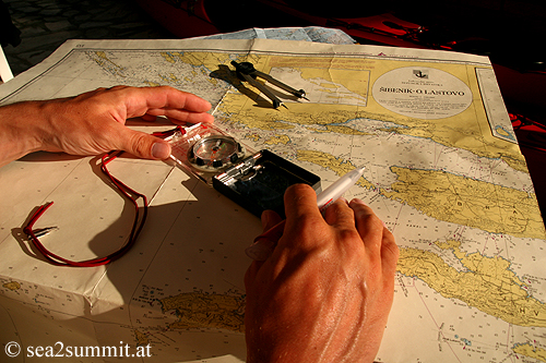
3 Charts published by the Hydrographic Institute of
the Republic of Croatia, Split (Hvratski Hidrografski Institut)
cover the coastline from Rijeka to Dubrovnik: Rijeka – O.Murter 1:200
000 (nr. 152), Sibenik – Lastovo 1:200 000 (nr. 153) , Peljesac – Rt
Ostra 1:200 000 (nr. 154)
See http://www.hhi.hr
the web site for the Hydrographic Institute of the Republic of Croatia,
Split, for Information about charts etc.